

Technology, Apps, and the Problem with Baxter Street
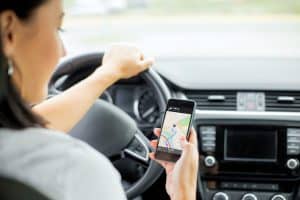 Technology and traffic apps can be a lifesaver for those of us trying to find our way around unfamiliar areas, or when we want to find a shortcut if we’re stuck in traffic during our daily commute. We might find ourselves in neighborhoods we never knew about before, on side streets that help us escape the bigger, car-clogged highways—all thanks to apps like Google Maps or Waze that automatically route us around accidents or traffic and bring us on a more efficient route.
However, these alternate routes aren’t always more efficient for everyone. Residents of these smaller neighborhoods are finding themselves in the middle of traffic nightmares and snafus from the increased volume of vehicles flooding into their streets as directed by mapping apps.
And one of the worst affected areas is Baxter Street in Los Angeles.
Baxter is one of the steepest streets in Echo Park and all of California, with a 32% grade. To put that into perspective, Lombard Street in San Francisco, one of the most notoriously steep streets in the country, has only a 27% grade.
Residents of the street are reporting an influx of drivers whose mapping apps are directing them down Baxter Street in an effort to avoid Glendale Boulevard. This is resulting in a surge of car accidents on their once-quiet, steep, and difficult-to-drive road. It seems everyone who lives on Baxter has witnessed an accident involving an unsuspecting driver trying to tackle the hill.
“The car came through our garden, went through two fences, and ended up backwards hanging over our driveway,” resident Jason Luther told the Los Angeles Times.
“Rain is a huge problem,” another resident, Robbie Adams, said. “People start skidding and spinning. We had our garden wall knocked down twice, and my wife’s car got hit in our own driveway. I’ve seen five or six cars smash into other cars, and it’s getting worse.”
Adams said he contacted Waze about removing Baxter Street from their app as a shortcut possibility, or at least posting a warning that the street is hazardous in wet weather. “They said they couldn’t do that because it involves changing the algorithm of the app in a weird way,” he said.
Google Maps also provided a statement regarding removing Baxter Street as an option:
Google Maps models the ever-changing real world by mapping for ground truth. This means that our map reflects any measures taken by local agencies to protect their citizens—for example, blocking off a steep road, or implementing turn restrictions. Should the local agency decide to restrict Baxter Street, this change will be taken into account when routing drivers through the Los Angeles area.
Representatives from the neighborhood are currently speaking with the LADOT to discuss ways to ease the traffic issues on Baxter. Possible solutions include turning one end of the street into a cul-de-sac, making the street one-way, or prohibiting left turns during certain times of the day.
Until then, Baxter Street may end up becoming a tourist attraction. Says resident Mark Stuplin, “We literally just sit on the front porch with a glass of wine and watch the chaos unfold. It’s better than Netflix.”
If you suffer injury in a collision due to someone else’s negligence or recklessness, the Los Angeles car accident attorneys at Taylor & Ring can help. We provide skilled and experienced representation throughout Southern California area to clients just like you. Call us today at 310.776.6390 or complete our contact form to schedule a consultation.
David Ring is a nationally renowned plaintiff’s personal injury trial attorney and has obtained multi-million dollar verdicts and settlements on behalf of seriously-injured individuals or families who have lost a loved one in a tragic accident. For more than 20 years, he has represented victims of sexual abuse, sexual harassment, assault, molestation and sexual misconduct in cases against a variety of employers and entities, including schools, churches and youth organizations.
He prides himself on providing aggressive, yet compassionate representation for children who have been sexually abused and women who have been sexually harassed or assaulted. Read more about David M. Ring.